 Pacific Coast Highway Master Plan Feasibility Study
Pacific Coast Highway Master Plan Feasibility Study
Overview
Caltrans District 7 is planning to identify and evaluate short-term, medium-term, and long-term potential projects and potential funding sources that could be implemented to improve safety and reduce the rate and severity of collisions within the portion of Pacific Coast Highway (PCH) in the City of Malibu – also known as State Route 1 (SR-1) in the State of California’s highway numbering system. PCH serves as a critical transportation artery in the City of Malibu as it contains, or provides access to, most of the City’s commercial, residential, and recreational areas.
In recent years, PCH in Malibu has seen numerous fatal collisions and severe injuries. The focus of this Feasibility Study is to identify transportation improvements that will address safety for all users with an emphasis on supporting multimodal travel options for pedestrians and bicyclists, as well as enhancing transit opportunities for the portion of PCH in Malibu.
For more information, click here to view the fact sheet.
PCH Draft Master Plan Feasibility Study Document
Pacific Coast Highway (PCH) – also known as State Route 1 (SR-1) in the State of California’s highway numbering system serves as a critical transportation artery in the City of Malibu as it contains, or provides access to, most of the City’s commercial, residential, and recreational areas. In recent years, PCH within Malibu has seen numerous fatal collisions and severe injuries.
In response, the California Department of Transportation (Caltrans) District 7 prepared the Pacific Coast Highway Master Plan Feasibility Study to identify and evaluate short-term, medium-term, and long-term potential projects and potential funding sources that could be implemented to improve safety for all users, support multimodal travel options, enhance transit opportunities, and reduce the rate and severity of collisions.
Information providing an overview and objectives of the Study is available below.
Overview and Objectives
Identification of safety priority areas, based on collision data.
Building upon implemented short-term, and planned mid-term improvements, identification and evaluation of long-term measures to improve safety for and interactions amongst vehicles, cyclists and pedestrians while preserving Malibu as residential community and tourist destination.
Identification of opportunities to incorporate features supporting safe travel options for all travel modes.
Public Engagement
Public engagement will be a critical and major focus of this Feasibility Study. The recommendations included in the Feasibility Study will be based upon and shaped by the priorities and input received from local residents, businesses, and other stakeholders. Public engagement efforts will be conducted through public meetings, surveys, and an interactive web page on Caltrans District 7’s website.
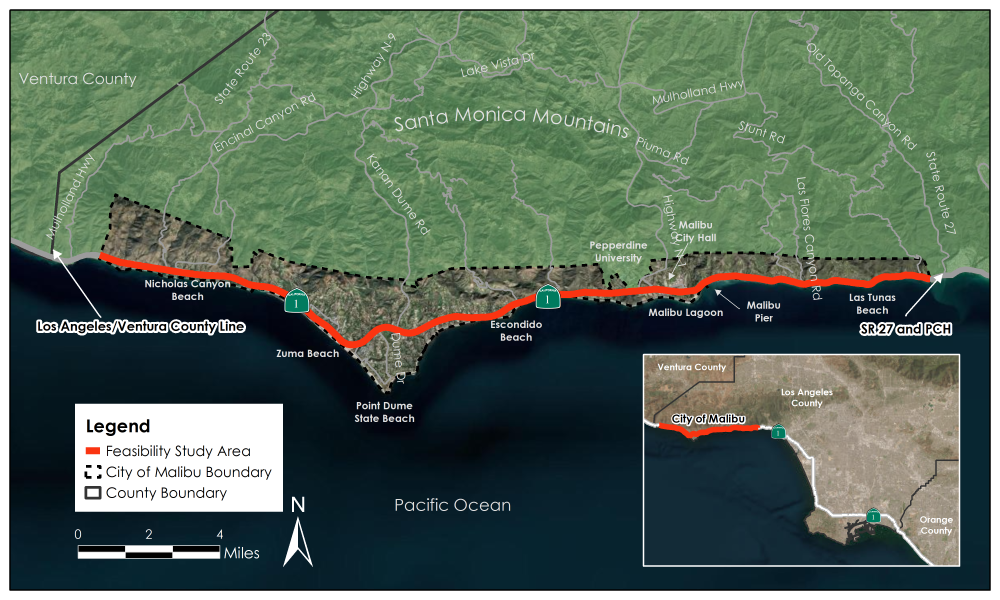
Study Area
This Feasibility Study focuses on the approximately 22-mile portion of the Pacific Coast Highway (PCH), a north/south highway in the State’s Highway System, located within the city limits of Malibu (from approximately 1700 feet north of the State Route 27/PCH intersection to approximately 1 mile south of the Los Angeles/Ventura County line). See map below.
Timeline