9TH Avenue Interchange Project
9TH Avenue Interchange Project
Caltrans District 6, in coordination with the City of Hanford and the Kings County Council of Governments, is preparing a project to remove and upgrade the 9th Avenue/State Route 198 Interchange.
Information
9TH Avenue Interchange Project PA&ED
Currently in PA&ED, this phase intends to obtain public input to inform the selection of a project alternative, identify land use needs, further define costs, and develop the necessary environmental...
Project Description
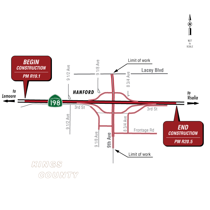
The California Department of Transportation (Caltrans) is starting its environmental compliance process and coordinating with the public for the 9th Avenue Interchange project. The project would construct an interchange on State Route 198 at 9th Avenue from post mile R19.1 to post mile R20.5 in Kings County.
Purpose and Need:
PURPOSE
• Provide Route Continuity for State Route 198
• Improve Traffic Access to and across State Route 198
• Improve Pedestrian and Bicycle Access on 9th Avenue
NEED
Provide Route Continuity
State Route 198 is a four-lane freeway from the 14th Avenue interchange to the State Route 43 interchange, except at 9th Avenue. At this location, State Route 198 becomes an expressway with an uncontrolled limited access intersection. According to the June 2016 State Route 198 Traffic Concept Report, the ultimate future designation for this segment of State Route 198 is a four-lane freeway. The 9th Avenue intersection is located between the 10th Avenue interchange to the west and the State Route 43 interchange to the east, leaving a gap in this segment of four-lane freeway.
Improve Traffic Access onto and across 9th Avenue and State Route 198
State Route 198 prevents movement along and from 9th Avenue. The State Route 198/9th Avenue intersection only allows for right turns from 9th Avenue onto State Route 198. Traffic on 9th Avenue can neither turn left onto State Route 198 nor cross over State Route 198. Southbound vehicles on 9th Avenue are required to travel about a mile to the interchange at Lacey Boulevard to go eastbound on State Route 198. Northbound vehicles on 9th Avenue are required to travel about a mile to the Reddington on-ramp in order to go westbound on State Route 198. Motorists needing to cross State Route 198 must detour about two miles to cross State Route 198.
Improve Pedestrian and Bicycle Access on 9th Avenue
Between Lacey Boulevard and Hanford-Armona Road, 9th Avenue is currently designated as a Class III bike lane according to the 2016 Initial Bikeway Plan and a Class II bike lane for the 2035 Full Bikeway Plan. Currently, 9th Avenue currently has no features of either a Class II bike lane or Class III bike lane.
In addition, neither bicyclists nor pedestrians have access across State Route 198 on 9th Avenue. Pedestrians and bicyclists traveling on 9th Avenue must detour to the State Route 43 interchange, which is two additional miles of
travel.
Map:
Partnerships:
- City of Hanford
- Kings County Council of Governments